Tuya River (BC)
Length: 106 miles
Days: 4-6
Class: II-IV (V)
Craft: kayak, packraft
Season: May-July
Permitted: No
Gauge: Tuya River Near Telegraph Creek
Map: click here
The Tuya flows through an extremely remote area of British Columbia. You won’t have cell service for the last six hours of driving (from either direction) to the float plane base, let alone on the river. The scenery varies between boreal forests, open plains, and spectacular canyons. The last day of whitewater contains some of the most incredible canyons anywhere. This river is home to far more moose, wolves, mountain goats, and bears than kayakers, so tread lightly and enjoy.
Access and Shuttle
Access for the Tuya is straightforward as far as remote float-plane trips go. The river starts at Tuya Lake, a large sub-alpine lake northwest of Dease Lake, BC. We flew in with a company called BC Yukon Air from Dease Lake for about $330 CAD a person (two flights, three people each). I think there’s at least one other company in the area that might be able to fly you in as well.
The takeout is at a road bridge that’s about 1.5 hours down a dirt road from Dease Lake (where you fly from). Shuttle is definitely hitchable, but if you have two vehicles in the area it’s an easy shuttle with a nice parking area right near the takeout bridge.
Permitting and Rules
There are no permits for this river although you do start in or near the Tuya Mountains Provincial Park (depending where on the lake you land). That said, this valley is quite pristine and the river itself is rarely paddled. Pay attention to fire conditions before your trip. If you do have campfires, be very careful, and do your best to practice Leave No Trace principles.
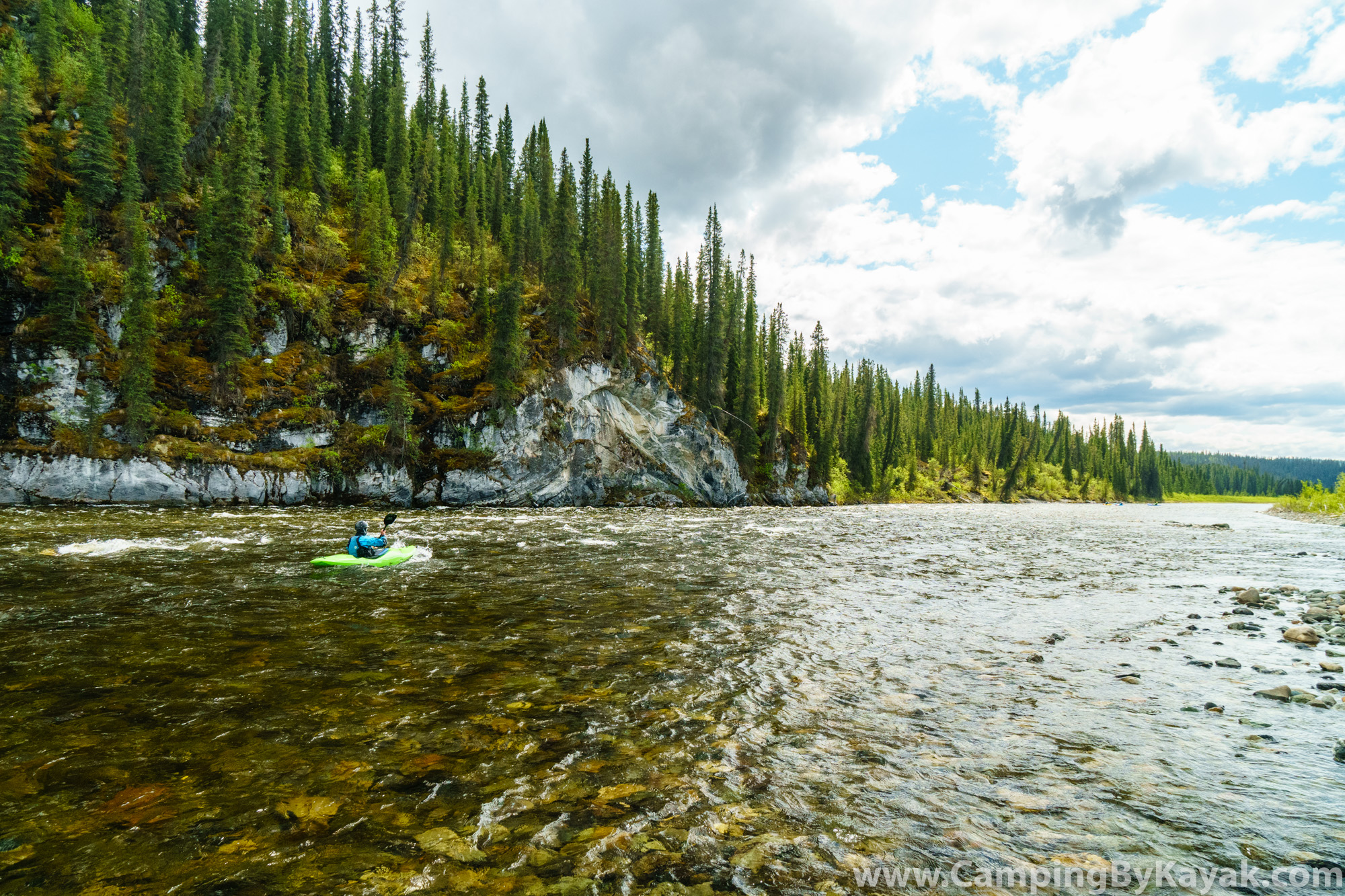
On the Water
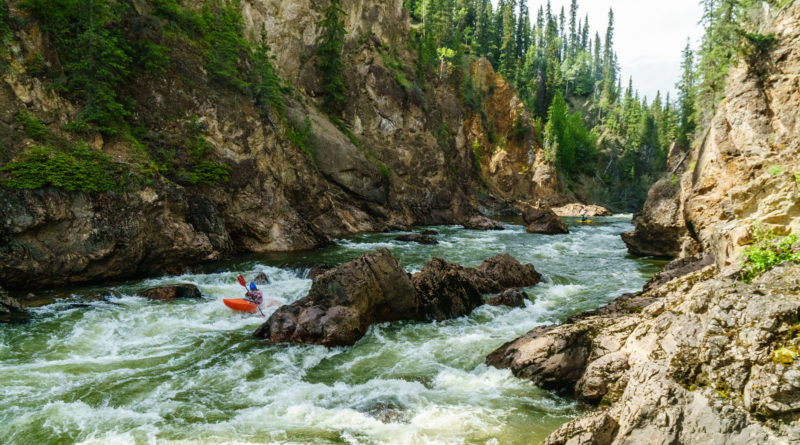
The first few days on the Tuya are primarily class II with open northwest BC scenery interspersed by occasional sections of easy but scenic bedrock canyon. About 65 miles in, the whitewater starts to pick up and the canyon walls grow. A series of fun read-and-run class III rapids in an impressive gorge lead to a walled in horizon line in a 300′ deep canyon. At our flows of around 45cms, this rapid was runnable class V, but impossible to scout in full and very difficult to scout at all. We opted to portage. The best route involved backtracking upstream (one short upstream portage and some attaining) to a break in the canyon wall on river right. We roped boats up one pitch and then followed game trails to the summit of a ridge (straight up fall-line). From there, a gradual traverse downstream (right) as you descend will bring you to the end of the canyon. At higher flows, it may be impossible to retrace your steps to this portage route if you commit all the way down to the horizon line. Portage route details and pin-points are available on the beta map. It takes about two hours but felt pretty easy considering the scale of the canyon you’re escaping and re-entering. At higher flows, this rapid may go more smoothly, but it may not. If you are thinking about attempting to scout or run the rapid, be prepared for a class V experience on an otherwise easy river.
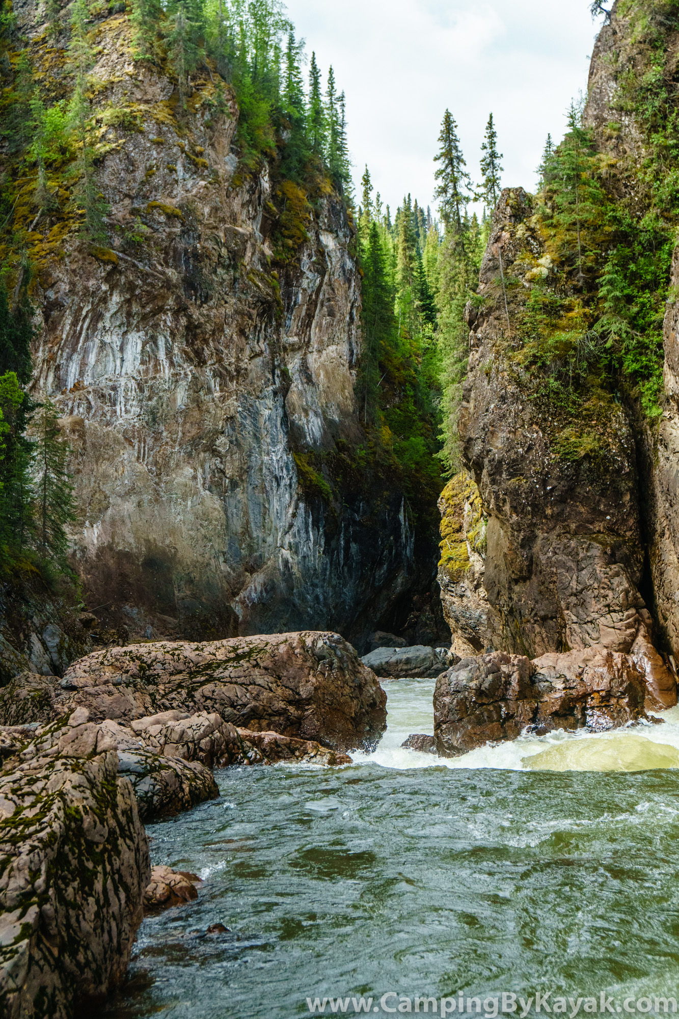
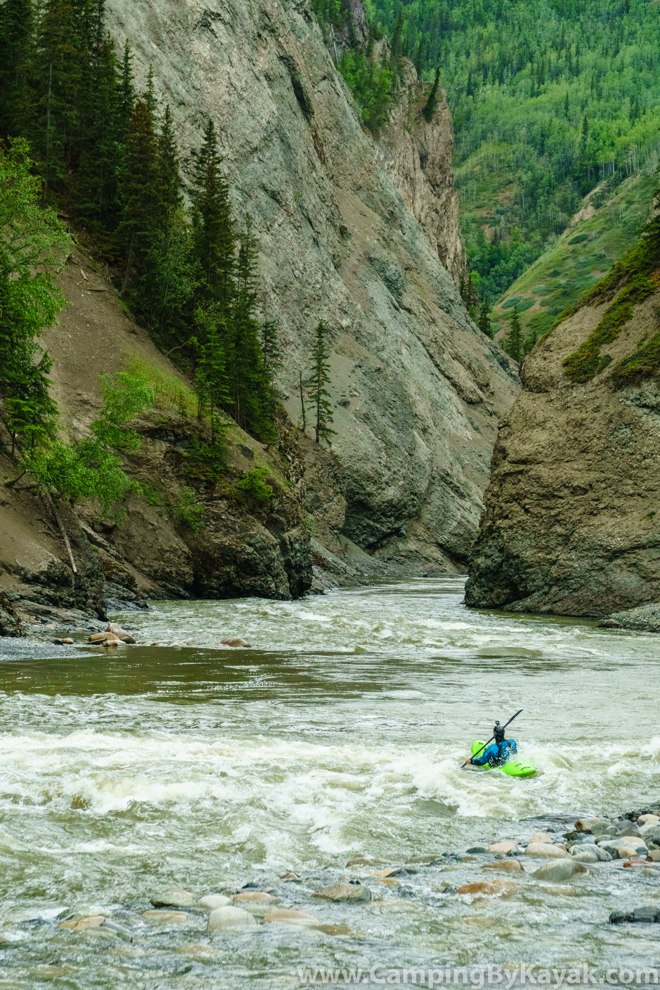
After the portage, the canyon picks back up with a few more kilometers of beautiful class III before mellowing out. Another day of class II, moose, bears, beavers, and wolves leads to the start of the real whitewater. The river steepens without canyoning up and goes through about 15km of pool-drop boulder garden class III and IV — really fun whitewater. At high flows, this might be pretty exciting. Eventually, the fun runs out, but as the whitewater flattens, the walls rise and the last few hours course through a huge gorge with mountain goats everywhere. As you leave the last canyon, you float into the remains of the 2018 wildfire and before you know it, the road bridge comes into view.
Alternate takeout: it is possible to continue beyond the road bridge into the Stikine and take out at the traditional takeout for the Grand Canyon of the Stikine. The Tuya enters the Stikine below all the major rapids, so it’s just a scenic float out once at the confluence, but to get there, you have to travel through a short but steep canyon below the road bridge. To my knowledge, this canyon has only been done once. My impression is that there is one very marginal waterfall and the rest of it is mostly fine, and I think you can portage that waterfall, but you’ll want to figure that out before you fully commit to it. Here’s a video of Todd Wells running the waterfall in question.
Water Levels
The information in this guide comes from a trip at 40-50cms on the gauge. We were hoping for higher water, but cold weather and a poor snowpack (2018) tanked the river just before we arrived. Median peak is around 200cms on June 1st after which the river typically trends downwards, generally bottoming out around mid-July. I wouldn’t paddle it lower than 40cms. The high water limit is unknown. At high flows, the canyon sections would become challenging and attempting to scout the portage at river level would be impossible, and you’d want to be careful not to miss the egress point for the portage. The read-and-run class IV towards the end of the run would likely stay class IV, but could be quite pushy. Overall, I think it’d be safe to plan on doing this river any time from May through September, but use caution at higher flows as the character would change significantly.

Wildlife
The amount of wildlife on this river is amazing but demands respect. We saw wolves, moose, beavers, more mountain goats than we could count, and tons of bear tracks. Surprisingly, no bears, but this is a bear heavy area. Bring bear spray (tell the float plane pilot so he can put it in the floats!), keep a clean camp, and give moose a wide berth. And, as always in northwest BC, bring a bug net.

Hiking
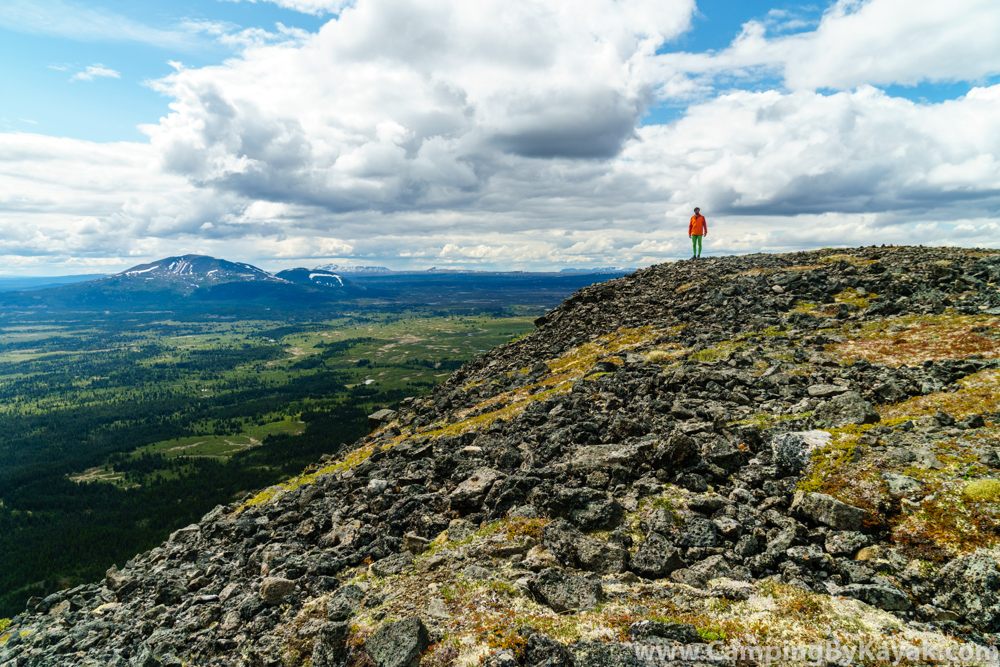
We flew in on the north side of Tuya Lake which allowed us to hike Tuya Butte before heading downstream. That added 10km of flatwater lake paddling, though, and while Tuya Butte was stunning and the plateau surrounding the lake is very unique country, I would consider flying in as far south as you can and spending the extra time hiking in the lower canyons instead.
More photos from this river are available here.


Great place and very good description …
Thanks Arturo! Were you on Lotar’s trip up there?