Kusawa River Trip Report
Until we arrived at the floatplane base in Whitehorse, we thought the only two descents of the Kusawa River were done nearly thirty years ago by the authors of the mysterious guidebook entry in “A Guide to Paddling in the Yukon.” According to Gerd at Alpine Aviation, though, a group of Americans had run it about ten years earlier with “more than twenty portages.” So — three descents, ranging from about a dozen portages by the guidebook authors to two dozen by the unknown Americans, plus a pretty skeptical look from Gerd as he was telling us about the previous trip he flew in. A history like that would lead any reasonable person to wonder why it’s been done so few times…and being the reasonable people they are, some Yukon friends planned this trip and invited me along.
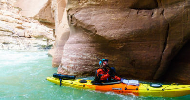
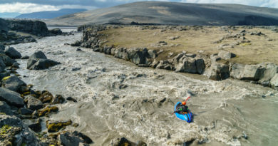
You can see what makes the Kusawa a unique trip from satellite imagery: most of the river is above tree-line and with a couple notable exceptions, despite significant gradient, the river is almost entirely wide open (not in a canyon). The experience of paddling through alpine meadows and weathered granite boulders with the glaciated mountains of the coast range a literal stone’s throw from your boat is truly special and the fact that it’s a class IV-V river is just icing on the cake.
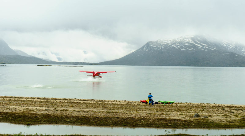
Our trip began with a socked-in takeoff from Whitehorse and a pilot — jokingly or not, I couldn’t tell — informing us we probably wouldn’t make it to the lake due to the weather. Luckily for us, the weather improved almost as soon as we left the bustling metropolis behind and began our climb into the alpine. As we climbed further up the river, the thick clouds yielded to stunning vistas of our put-in lake, and of the fresh coat of snow just a hundred meters above. So much for July, eh?
We got a taste of North-country mosquitoes while waiting for the second flight to come in, so once they’d landed, we wasted no time putting in and navigating our way through the maze-like outflow of Goodwin Lake and into the Kusawa. The river meandered its way through hummocky terrain filled with granite boulders and small ponds, tumbling over and through the boulders every now and then. A number of fun class III rapids led to one nearly river-wide sieve, and then to a big, shallow cascade. There was quite a bit of pondering about this first major rapid, but ultimately, no takers.

A member of the team who had to cancel last minute had gone through on Google Earth and marked waypoints at every major rapid; I had these waypoints on a map on my phone, so we knew when we were approaching the larger drops. Our first portage was marked “Stout 1.” Shortly after it, we encountered “Stout 2,” another drop that would set a theme for many of the bigger rapids of the trip: marginal but good class V followed by an impassable sieve fence with no way to get out between. Fortunately, Stout 2 was followed by some of the more fun class IV of day one.


The Stouts let up and we found ourselves floating into another alpine lake with the sun shining and a tributary cascading in directly from the glaciers above us. We made camp and went for a hike up the tributary.
It can be hard to get enough sleep when you’re camping in the north in the summer; there’s no visual cue that it might be time to call it a night. The normal “oh it’s dark, must be time for bed” that usually leads to a solid twelve hour night of sleep just doesn’t happen. If you’re lucky, though, you get some other kind of cue that will drive you towards your tent. Like pouring rain or heinous mosquitoes. We got both, and as a result, I got a good night’s sleep.
The river has a bit more volume on day two thanks to a few tributaries and many of the rapids are more channelized by bedrock. Some quality class III and IV lead to the next Stout, a walled-in three-stage rapid that, continuing in the tradition established by Stout 2, is a beautiful class V rapid followed by an impassable sieve fence. Darn. I’ve done worse things than above tree-line portaging through meadows of wild flowers, though.
More fun whitewater lead to another scout (Stout), a narrow entrance over a chunky five foot ledge above an undercut wall. We all walked, though this rapid is quite runnable, and put in below for one of the more fun and continuous sections of class IV thus far.

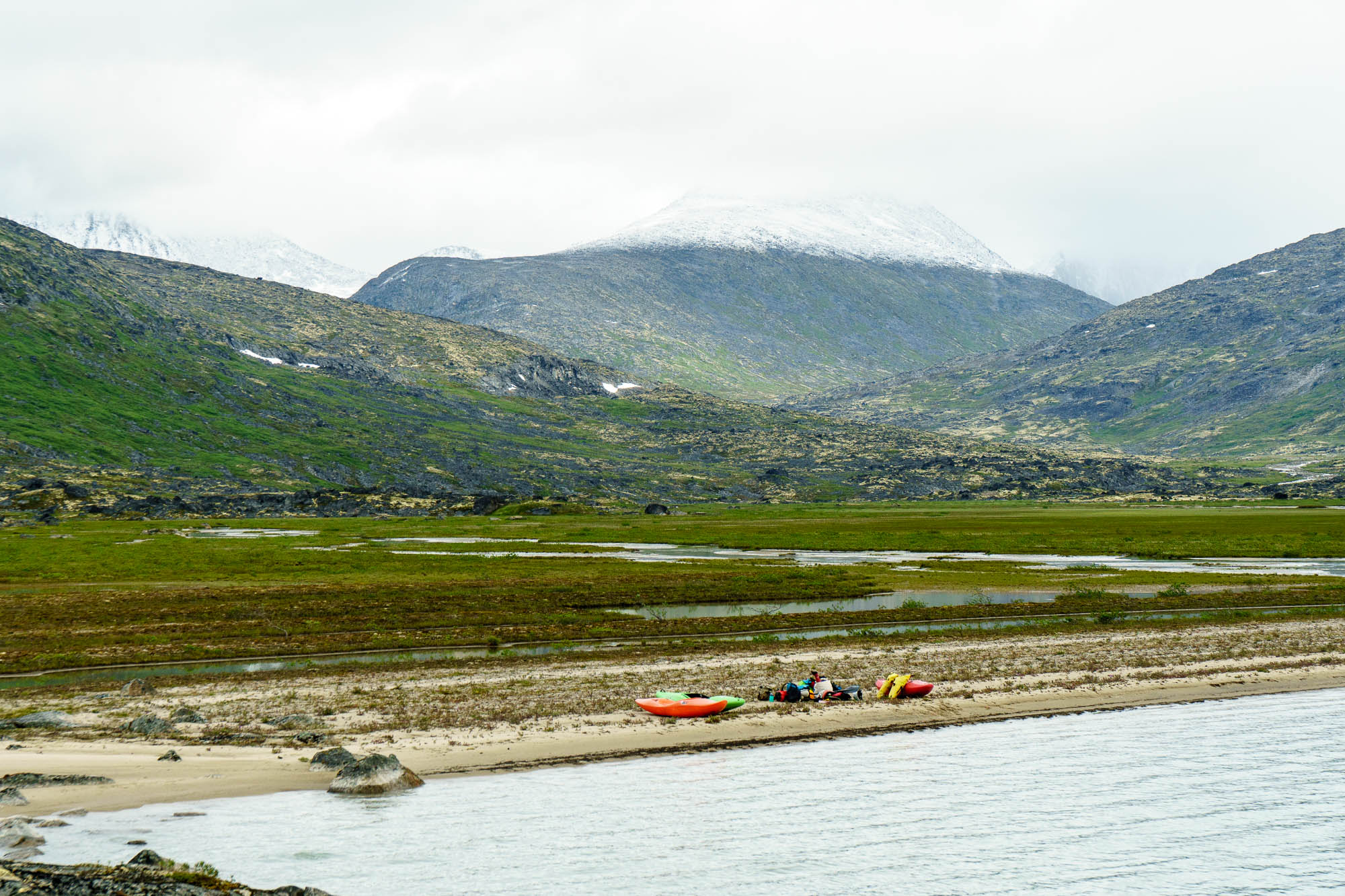
The portage around Stout 5 deposited us in some braided moving water and we floated downstream taking in the scenery and the sun. Eventually, the braids give way to another lake littered with invisible sandbars. Strategic flatwater navigation and, for some, wading with our boat in tow, led us to a beautiful island camp. Lots of bear tracks and scat in this area, but no bears.

The river flows out of the lake through some rocky shallows straight into what was marked “Stout 6” on our map. Stout 6, it turns out, is just a shallow and wide class IV rapid, but not far below lay Stout 7, another marginal multi-stage waterfall filled with rocks. Not to worry — we were getting pretty good at portaging by this point and made quick work despite the growing height of the shrubberies as we descended towards tree-line.
Around the corner, the Kusawa narrowed and steepened and we found ourselves in what’s probably the best, longest section of class IV on the run, also known as “Stout 8.” It’s boat-scoutable, but a few blind corners and memories of previous horizon lines had one of us hopping out to take a look in a few different spots.

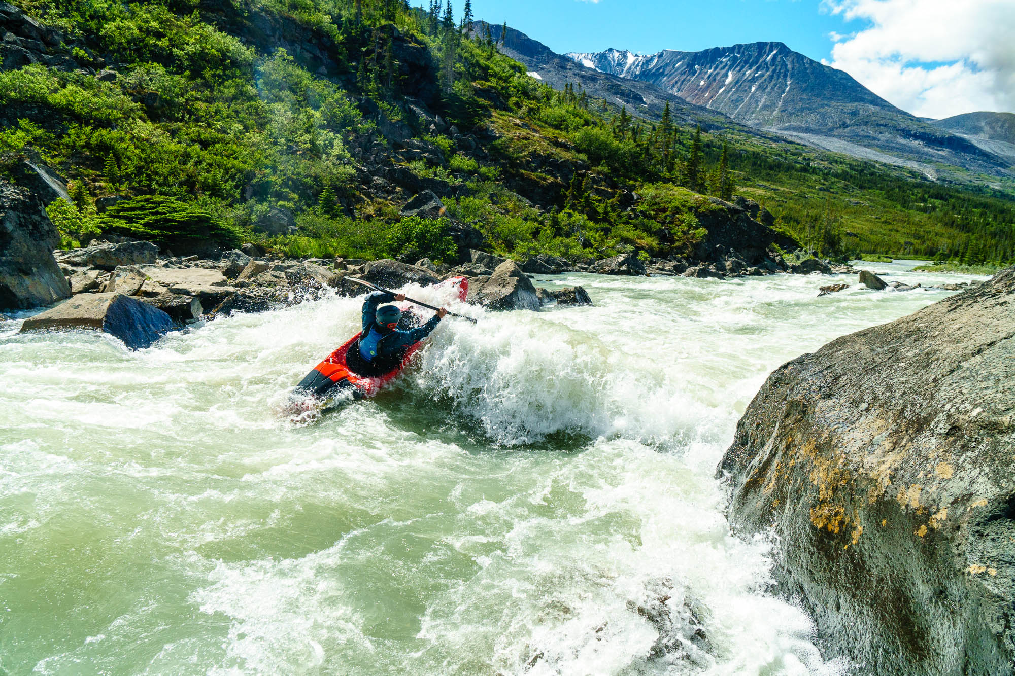
The whitewater really picked up in this area with more continuous class III and easy IV leading to Stout 9, the crown jewel of the Kusawa, an actually runnable but very large class V rapid. The river rounds a corner and gorges up, heading over two river-wide ledges, down a slide into a hole, and over a massive rooster tail. Most of us were in a portaging mood at this point, but Lawrence fired it up with a great line.

The next big rapid was a rocky ~15′ waterfall; we ran the class IV entrance and walked the main drop. More great whitewater lead into the final Stout of the trip, a fun looking lead-in into a 30′ un-runnable waterfall. Being below tree-line, this was the worst portage yet, but still only took about 15 minutes once we committed to it.

After the waterfall, we rounded the corner to find another scout and some of the best whitewater of the trip, a constricted and fun section of IV-IV+. Rapids continued for a bit, then mellowed to fast class II for the duration of the day and we made camp in a beautiful glade of trees on the left.
The last day had a few more fast and splashy class IV rapids then gradually mellowed as we approached Kusawa Lake. The last few miles of river were braided and flat and we managed to cut off some distance by portaging an oxbow. As we approached the lake, the river spread and shallowed and it became hard to find deep enough channels to float. We tried different approaches with varying degrees of success; everyone had to drag their boat at one point or another.

Kusawa Lake is about 70km long from the mouth of the river to the campground (and the road). It’s a stunning part of the Yukon and quite close to Whitehorse…but we weren’t about to paddle 70km of lake in creekboats, so the Yukon guys had hired their friend to come pick us up. We paddled a bit more than 5km on the lake to a camp on the right and Joe met us there that evening with a fresh supply of beer and hot dogs. We camped and he towed us out the next day…an experience I hope not to repeat. It turns out, small boat plus six paddlers and kayaks in tow equals about 12 km/hr. A cumulative six hours of towing (with a few lakeside breaks) and a two hour drive brought us back to civilization, another great trip in the books. I would recommend booking a float plane back from the end of the river to town…

The Kusawa isn’t an “ultra classic” from a whitewater perspective, but it’s good, and it’s not every day you get to paddle quality whitewater above tree-line for multiple days. I hope it’s not another 10-30 years before another group does it!
Stay tuned for a beta page on this run so you can plan your own trip!

Pingback: Kusawa River (BC, YT) - Camping By Kayak
Would you mind if I used one of the images from this post as a reference picture for a painting?
Hi Doug, go for it! I’d love to see the finished product when you’re done if you don’t mind though!
Nick
Nick: https://twitter.com/dougrutherford/status/1328823557460148231?s=19
Looks great!
Any chance I can get my hands on the stout map pins?
Also, did you try to determine the flow anyway?
If you click through to the map from the river guide page, then click on the three dots, you should see a “Download KML” option from there.
I think the flows guesstimating was pretty rough based on the group’s historical knowledge of the broader area (i.e. upper Tatshenshini and nearby runs).
Hey Nick! How many people could you fit per plane with Apline Aviation? We are planning to do this trip early July if it all works out. Looks amazing. Any other helpful logistics information you could share would be great. Thanks!
Hey Ben,
We did two flights for six people. I’m not 100% sure what other planes they might have; in other regions I’ve done as many as five in a single trip with an Otter.
Not sure I’ve got any other logistical tips but if any specific questions come up don’t hesitate to ask!